by Merle Ann Loman | Aug 9, 2009 | Bitterroot, ii Summer
This summer has been busy and the fishing has been great. One nice thing is that we haven’t had many wildfires so the air quality is very clear. I am enjoying that! Our rivers levels have been ample though in late July, the water temperatures were creeping up. But now, we have had cooling rain, a little too much rain as the river has been running a bit muddy from run-off sediment.
This last week we had a pacific and a canadian weather system collide over our big sky and it dumped record breaking rain amounts. The Bitterroot and Big Hole doubled their water levels. The fishing hasn’t been very good except on the Blackfoot River. It fished well yesterday.
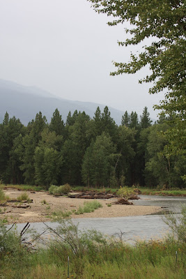
I am posting a few photos taken at Victor Crossing on the Bitterroot a few days ago to give you an idea of what our river looks like right now. As the storm passes and the sun comes out, the river should clear and the trout will be hungry.
To see graphs and other information from the USGS site click Wapiti Waters Stream Flow Links.

by Merle Ann Loman | Aug 6, 2009 | Blackfoot, ii Summer
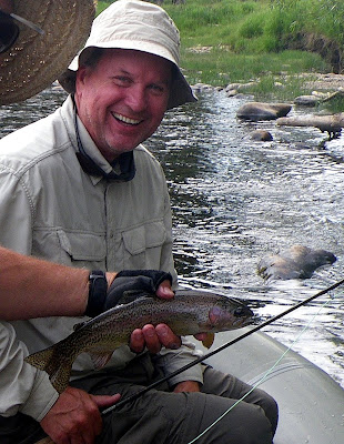
Carol from Milwaukee and Alan from Big Fork and CA fished the Blackfoot River with Jack on Wednesday. They started early so they could beat the heat and I think it paid off. Looks like the catching was good. I know the scenery was.

by Merle Ann Loman | Aug 5, 2009 | Big Hole, ii Summer
Doug Nation and Jack Saunders fished the Big Hole River with Jack on Monday. They didn’t get photos of the biggest fish Doug caught or of Jack Saunders’ fish, darn it. But they all had a great day of fishing and catching.
All three, Doug Nation, Jack Saunders and Jack Mauer are past-Presidents and active members of the Bitterroot Chapter of Trout Unlimited. Doug is currently Chairman of Montana Council of Trout Unlimited.
Click this Montana Trout Unlimited Newsletter link for the newest newsletter online.
To read about Montana Trout Unlimited see the website http://www.montanatu.org./
To read more about Bitterroot Trout Unlimited see the website http://www.brtu.org/
by Merle Ann Loman | Aug 4, 2009 | Big Hole, ii Summer
Jack has been enjoying the Big Hole this month. He had an especially fun day with Joe W and his friend, Gregg. They came over from Washington to fish a few rivers in Montana. Today was the Big Hole River.
by Merle Ann Loman | Jul 31, 2009 | Bitterroot, ii Summer, News bulletins
Information from and email by Larry A. Schock, CFM DNRC Water Resources Division
Hello Everyone,
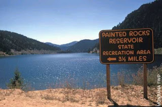
The DNRC has received several inquires lately concerning the outflows at Painted Rocks Reservoir and how the reservoir is operated. Therefore, the following email will provide a brief explanation of reservoir operations.
The operation of Painted Rocks Reservoir involves three main parties. The DNRC, the Painted Rocks Water Users Association (PRWUA), and the MT FWP. Painted Rocks Reservoir holds approximately 32,656 acre-feet (af) of water, with 25,000 af of that stored water marketed to the MT FWP and the PRWUA. Additionally, there is the Bitterroot River Water Commissioner who manages the river in a manner that insures the apportionment and diversion of decreed and contract waters.
The DNRC is owner of the dam and the reservoir area. It is our responsibility to insure that the reservoir is filled and operated safely and that water is available for delivery to the contract holders. Once the reservoir is full the amount of water that flows into the reservoir equals the reservoir outflows. The reservoir is held in this state of equilibrium until the contract water is requested. The DNRC is under contractual obligation to deliver the contract water a the dam to the contract holders when it is called for.
The 10,000 af (or 2/5ths) of shares that has been marketed to the PRWUA is primarily used for agriculture purposes. Releases to the PRWUA usually occurs in mid July, but it is delayed this year due to higher than normal flows on the East Fork and the Mainstem of the Bitterroot River.
The other 15,000 af (or 3/5ths) of shares has been marketed to the MT FWP for in-stream uses . The local FWP contact in the Bitterroot Valley is Chris Clancy at 363-7169. The FWP contract water is released for instream flows in the mainstem of the Bitterroot River, based upon the conditions at Bell Crossing. According to the FWP current guidelines, they determine their desired releases based upon a minimum targeted flow rate of approximately 450 cfs at the Bell Crossing gage. As of today the flow rate at the Bell Crossing gage is approximately 737 cfs. The current FWP guidelines do not discuss the release of water from the reservoir for the augmentation of flows in the West Fork of the Bitterroot River, only the mainstem of the Bitterroot River.
Recently inquires have been made to the DNRC about the following issues; low water levels effecting raft access to the river; low water levels effecting quality of fishing; low water levels effecting water temperatures; and bad access road into the shuttle parking area upstream of the USGS gage below the dam.
Low Water Levels
The low flow conditions in the West Fork of the Bitterroot River are simply a reflection of the low inflows into the reservoir. As inflows to the reservoir drop, the DNRC adjusts outflows to match. The DNRC is passing all of the inflows through the reservoir, either over the spillway or out of the low level outlet. Flows below the dam will raise, pending a call for contract water from either the PRWUA of the MT FWP. The DNRC has recently made several gate adjustments on July 23rd, 24th, and 28th in order to insure that the reservoir outflows matched the inflows. These adjustments are also needed in order to transition the flows from the spillway to the low level outlet in preparation for the anticipated contract water deliveries. An additional adjustment is anticipated on July 31st. Requests for the release of contract waters for in-stream purposes on the West Fork of the Bitterroot River should be directed to the FWP.
The dirt road that goes upstream past the USGS gage to the pioneer launch site below Painted Rocks Dam, is not a DNRC road and it is located on US Forest Service (USFS) property. Any concerns about this pioneer road, launch, and camping site should be directed to the USFS West Fork District Ranger Office.
Larry A. Schock, CFM
DNRC Water Resources Division
Missoula Regional Office
(406) 721-4284
lschock@mt.gov
Click here to go to the Montana Fish, Wildlife, and Parks (MT FWP) site for the West Fork of the Bitterroot.
Click here to go to the MT FWP site for Painted Rocks Reservoir, Tributary of the West Fork of the Bitterroot. They have an interactive map link.
Click here for contact information for US Forest Service, West Fork Ranger District.
 This summer has been busy and the fishing has been great. One nice thing is that we haven’t had many wildfires so the air quality is very clear. I am enjoying that! Our rivers levels have been ample though in late July, the water temperatures were creeping up. But now, we have had cooling rain, a little too much rain as the river has been running a bit muddy from run-off sediment.


