by Merle Ann Loman | May 29, 2009 | Bitterroot, i Spring
 Despite fairly warm temperatures, with no rain the Bitterroot River has been up, but with stable flows.
The slideshow shows Victor Crossing and it is looking very similar to my previous photos except for the new, large pine tree deposited in the middle just up (south) from the bridge. That will be fun to row around, not.
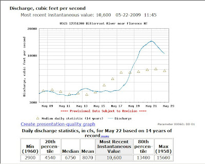
Click the chart to visit the USGS site.

by Merle Ann Loman | May 24, 2009 | Bitterroot, i Spring
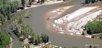
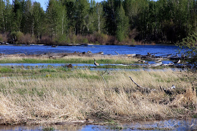
Jack added some captions to the slideshow. This coming week is going to be hot! The snowpack will be coming off in a hurry! Stay tuned. Here are some photos from Jack’s flight over the Bitterroot River on May 22, 2009. It is not in flood stage but definitely in run-off. The photos begin near Woodside, travel downstream (north) to MacClay’s near/north of Poker Joe, then turn and head back upstream (south) to finish near Darby.
by Merle Ann Loman | May 22, 2009 | Bitterroot, i Spring

Here is a slideshow for photos from Victor Crossing. The first photo is May 11 and the last is May 22.
Today the river is dropping but if the weather warms a lot, it could rise again as the snow-pack melts.
For now, it is below flood stage except in the very low areas.
Jack is flying over the river as I type this with a friend. I will blog some photos from the flight when he gets home.
Click here for Wapiti Waters USGS Stream Flow Links.
by Merle Ann Loman | May 20, 2009 | Bitterroot, i Spring
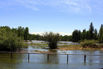
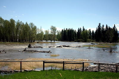
The photo is of the Bitterroot River south of Victor Crossing. It was taken yesterday about 2:00 pm. Since then, it rose about 3000 cubic feet per second (CFS) – from approximately 10,000 to 13,000 CFS.

The National Weather Service has issued a flood warning, as of Tuesday afternoon, for the Bitterroot River in the Darby and Victor areas.
With tributaries rising on the heels warm weekend temperatures, officials with the National Weather Service say rapid snow melt has raised the likelihood of flooding.
The Bitterroot River was measured at 7.3 feet late Tuesday morning, with flood stage at 7.5 feet. The National Weather Service warns that flood waters can be expected to inundate several roads in Ravalli County.
The service issued a flood watch for the South Fork of the Clearwater River near Stites, Idaho. The South Fork of the river is expected to reach flood stages late Tuesday or Wednesday morning.
From the RAVALLI REPUBLIC Online.
Click here for Wapiti Waters links to USGS Streamflow Data – River water level information.
I will post a slideshow soon of the river from normal levels, to higher levels, to flood stage (if it happens) at Victor Crossing.

by Merle Ann Loman | May 18, 2009 | i Spring, Missouri, Take Your Kids Fishing

Jack fished the Missouri River with his son-in-law, Marshall Knick. It was coming up, the water was a bit cloudy but the managed to hook some fish. Jack caught this fish and Marshall is holding it. Josh Lauer has a photo of Marshall and the bigger brown that he caught. When Josh sends it to us, I will post it, too.
I had to include photos of Jack’s daughter, Hannah – of course married to Marshall, and their son’s Tristen and Tait!
See the photos in the Picasa slideshow below.
 Despite fairly warm temperatures, with no rain the Bitterroot River has been up, but with stable flows.


