
by Merle Ann Loman | Jun 11, 2009 | Bitterroot, i Spring

John fishes with Jack pretty regularly. John is a retired (more than once) Marine, neighbor and good friend. He is also “godfather” to our Chesapeake puppy, Freda. Yesterday we fished a stretch of the Bitterroot mainstem Jack hadn’t been down since high(est)-water. The water level was at about 3000 CFS – fairly big, but clear. John wanted Freda to come, too. In order to be safe and keep Freda in tow (or more accurately, in the boat), I got to come along as dog-sitter. I did get to catch some fish, too!
We saw a LOT of wood – new wood, the big kind with green leaves – in the river. In the slideshow you will see John play a fish and I will include some photos of Freda and new “trees” in the river.
If you are floating the Bitterroot while the water is fast, be sure to do your homework and have safety flotation devices. The hydraulics are dangerous and often difficult to predict. I didn’t take photos of the biggest rocks and obstructions because Jack made me put my camera away. Wise choice.
Along the way, we saw herons, ducks, osprey, eagles, kingfishers, Lewis’s Woopeckers and many more small birds. Those photos are for another blog entry.

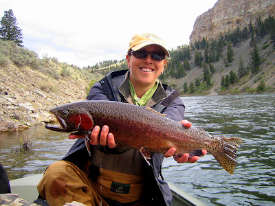
by Merle Ann Loman | Jun 10, 2009 | Big Hole, i Spring, ii Summer

Jack and Dave Heimes guided some of our favorite clients on the upper Big Hole yesterday. Mike was out numbered by three women, Susan, Peggy and Joyce. It was big water, but not too big and the conditions were “pre-salmonfly hatch.” Susan could hardly stop catching. She caught fish after fish after fish! Peggy was the designated photographer with Jack’s camera.

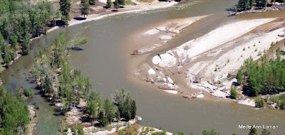
by Merle Ann Loman | Jun 2, 2009 | Bitterroot, i Spring

Victor Crossing looks pretty much the same as my photos a few days ago so I decided go north (downstream) a few miles to take photos of Bell Crossing. Today the middle river gauge says 13,400 CFS – down from the peak of about 15, 600 CFS two days ago. The water is still a muddy brown, but I don’t think there will be more than minor flooding. No rain is expected for the near future.
by Merle Ann Loman | Jun 1, 2009 | i Spring, Missouri
 Stephanie Lauer on the Missouri River in May. Steph and Josh spent some time on the “Mo” and sent me these photos.
We are at high water here in the Bitterroot so I am featuring a few friends.
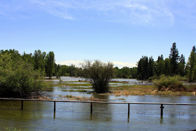
by Merle Ann Loman | May 29, 2009 | Bitterroot, i Spring
 Despite fairly warm temperatures, with no rain the Bitterroot River has been up, but with stable flows.
The slideshow shows Victor Crossing and it is looking very similar to my previous photos except for the new, large pine tree deposited in the middle just up (south) from the bridge. That will be fun to row around, not.
Click the chart to visit the USGS site.

by Merle Ann Loman | May 24, 2009 | Bitterroot, i Spring
Jack added some captions to the slideshow. This coming week is going to be hot! The snowpack will be coming off in a hurry! Stay tuned. Here are some photos from Jack’s flight over the Bitterroot River on May 22, 2009. It is not in flood stage but definitely in run-off. The photos begin near Woodside, travel downstream (north) to MacClay’s near/north of Poker Joe, then turn and head back upstream (south) to finish near Darby.


