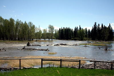
The photo is of the Bitterroot River south of Victor Crossing. It was taken yesterday about 2:00 pm. Since then, it rose about 3000 cubic feet per second (CFS) – from approximately 10,000 to 13,000 CFS.

The National Weather Service has issued a flood warning, as of Tuesday afternoon, for the Bitterroot River in the Darby and Victor areas.
With tributaries rising on the heels warm weekend temperatures, officials with the National Weather Service say rapid snow melt has raised the likelihood of flooding.
The Bitterroot River was measured at 7.3 feet late Tuesday morning, with flood stage at 7.5 feet. The National Weather Service warns that flood waters can be expected to inundate several roads in Ravalli County.
The service issued a flood watch for the South Fork of the Clearwater River near Stites, Idaho. The South Fork of the river is expected to reach flood stages late Tuesday or Wednesday morning.
From the RAVALLI REPUBLIC Online.
Click here for Wapiti Waters links to USGS Streamflow Data – River water level information.
I will post a slideshow soon of the river from normal levels, to higher levels, to flood stage (if it happens) at Victor Crossing.
