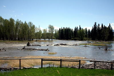
The photo is of the Bitterroot River south of Victor Crossing. It was taken yesterday about 2:00 pm. Since then, it rose about 3000 cubic feet per second (CFS) – from approximately 10,000 to 13,000 CFS.
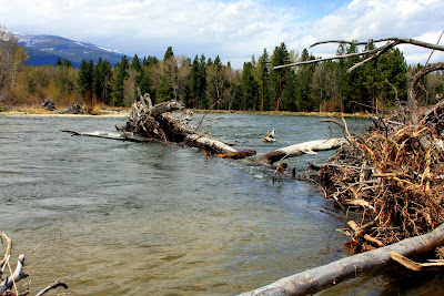
The National Weather Service has issued a flood warning, as of Tuesday afternoon, for the Bitterroot River in the Darby and Victor areas.
With tributaries rising on the heels warm weekend temperatures, officials with the National Weather Service say rapid snow melt has raised the likelihood of flooding.
The Bitterroot River was measured at 7.3 feet late Tuesday morning, with flood stage at 7.5 feet. The National Weather Service warns that flood waters can be expected to inundate several roads in Ravalli County.
The service issued a flood watch for the South Fork of the Clearwater River near Stites, Idaho. The South Fork of the river is expected to reach flood stages late Tuesday or Wednesday morning.
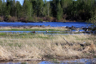
The photo to the right is from May 11 at Victor Crossing which is about the middle of the Bitterroot. You can see that it is fairly clear and big, but not bank-full or in the run-off stage.
The weather this spring has been cool, cool, cool. The photo below was taken May 12. Yes, it was snowing. The snow-pack in the mountains is growing not shrinking.
Take a look at the weather widget to the left in the sidebar. It is forecasted to be 85 degrees this Sunday and Monday. That is going to be interesting!
Jack and Casey went to the Clearwater Chain of Lakes yesterday. It was cold and a bit windy but they caught some pike. No camera, so I can’t post any photos of that trip.
Tomorrow, Jack is going to the Missouri River to fish near Craig, Montana. It might still be cool and windy, but we will find out how the fishing is.
Stay tuned for a look at our rivers. I will be posting photos when I can.
See the sidebar for links to USGS water data and if you go near the rivers, please be very careful. The water is very, very cold, approximately 38 degrees.
We drove through the Big Hole Valley a few days ago on our way to Bozeman and Billings. The slideshow below starts just east of Lost Trail Pass (it was snowing on our way over) and then visits the Big Hole River near Wisdom, Wise River, and Divide, Montana. Click the town names for more information on the Visit Montana site.
The river was big and fast, the weather was overcast and in the 45 degree range, but we saw a few boats with people fishing…not sure what the success rate was.
Jack is a permited Fly Fishing Outfitter for the Big Hole, has fished and guided on it for over 30 years, and loves that special high mountain valley. Click Wapiti Waters Big Hole web page for more information, including more links.